
Local Color: Boston
🎓 Master Thesis
Deconstructing architecture for wayfinding
How can you transform architectural elements of a neighborhood or city and use them to better guide people through it and foster a greater appreciation of those elements?
Role
Research, UI & UX Design
Recognition
Exhibited: Departure Point (2012), Digitas Boston
Spotlight: The Graphic Design Blong (2013)
Overview
My thesis concept was driven by my experiences creating murals and public art in Boston. Growing up in a part of the city disconnected from the rest of it, working on those projects was how I came to learn more about the city and navigate it. It helped instill an interest in the interactions between design, environments, and the people within them. I wanted to use my experiences to find a way to help others navigate and appreciate the city. That led me to the concept of a wayfinding system that integrated with the architectural identities within the city.
Process
My process was broken into 4 main phases: research, visual exploration, studio, and documentation.
Thesis Research
How can we as designers cause people to think about a topic, or transform their surroundings into not just physical structures, but organic and responsive environments in which viewers can participate and interact?
My research focus was an exploration of how murals can inspire the design of more interactive environments and how they encourage dialogue and as well as inform the viewer.

“Murals are such monumental tasks. They changea space in how it can be perceived and transformed. They impacthow people feel whether it is for a moment, for a day, or for the rest of their livesas they pass it by.” Quote: Susan Shian
Starting my research, I had my own history and experiences with murals to help guide and give me a start. I had been working with the Mayor’s Mural Crew in Boston for nine years, working with communities and high school students across the city, designing and painting murals. To gain a better understanding, I started asking people—including other mural painters—what murals meant to them and how they would describe them. Gathering their stories, parts of which are in my documentation, I had three questions to frame my research around that helped provide me with a framework for moving forward:
What is a wall?
What are murals?
How do they encourage interaction?
Built out of that research, this was my thesis statement:
Tapping into the transformative and communicative aspects of murals, I would like to devise some kind of system or installation that could be adaptable to different environments, virtual or physical. The system would be interactive and responsive; have an interface or environment that allows people to alter what is around them as well as transmit and receive thoughts.
Visual Research
The aim of my thesis work was to create a wayfinding system for the city of Boston; one that was inspired by murals. My objective was to create a wayfinding system that was informed by and build off from the surrounding environment. It was also important that the wayfinding system help people find their way and learn about the area around them.
I wanted to help both tourists, who new to the city, and residents, people who are often tourists in the city once they leave their own familiar neighborhoods. I also wanted people to become more aware and see their surroundings in a light by interacting with the system.
I had people select four Boston neighborhoods from a survey that they felt could use a wayfinding system the most. Based on the results, I narrowed my focus to the neighborhoods of Back Bay, Chinatown, South Boston, and the North End. To gain better insight and visuals of the different environments, I grabbed my camera and went exploring in each neighborhood. The photos that follow are from each of the neighborhoods.

Example photos from the North End, with motifs pulled out.
While studying the photos, I noticed how certain shapes and patterns repeat in each neighborhood, like those engraved in the sidewalks of Chinatown, the brick patterns of the North End, or in the iron work of the South End. I explored how those shapes could create the visuals of my wayfinding system and how they could show the personality and identify each of the four neighborhoods. Together, those pieces would inform my studio work.
Thesis Studio
Going through my photos and research into each of the four neighborhoods, I was able to assemble a “kit of parts,” a collection of elements which I could mix and match to create the visuals and various aspects of my wayfinding system.
Neighborhood identifier colors
Neighborhood identifier colors
Neighborhood identifier colors
Using that kit of parts, I started to explore what different wayfinding tools and installations could look like, including signage at T stations, crosswalks and other street and sidewalk graphics, mural identifies at different landmarks, and informational kiosks and maps.

Sidewalk graphic example: Back Bay

Information kiosk example: Chinatown
On top of that, I needed to name and brand the system as a whole and make a plan to market it. It’s a system that guides people, but it also shows local identity and history. Playing off that idea, I decided to call my system, Local Color.
In literature, local color refers to writing that uses characteristics of certain area, be that history, landscape, or dialect. In visual arts, local color can either be the natural color of an object, without any added distortion, or it can also refer to the use of raw material.With those meanings, local color made a perfect fit for what my system aims to achieve. It also opened up the opportunity for adding some local color in terms of the language of the advertising I designed to promote the system.
Logo for Local Color
Sample ads for the system
Thesis Results
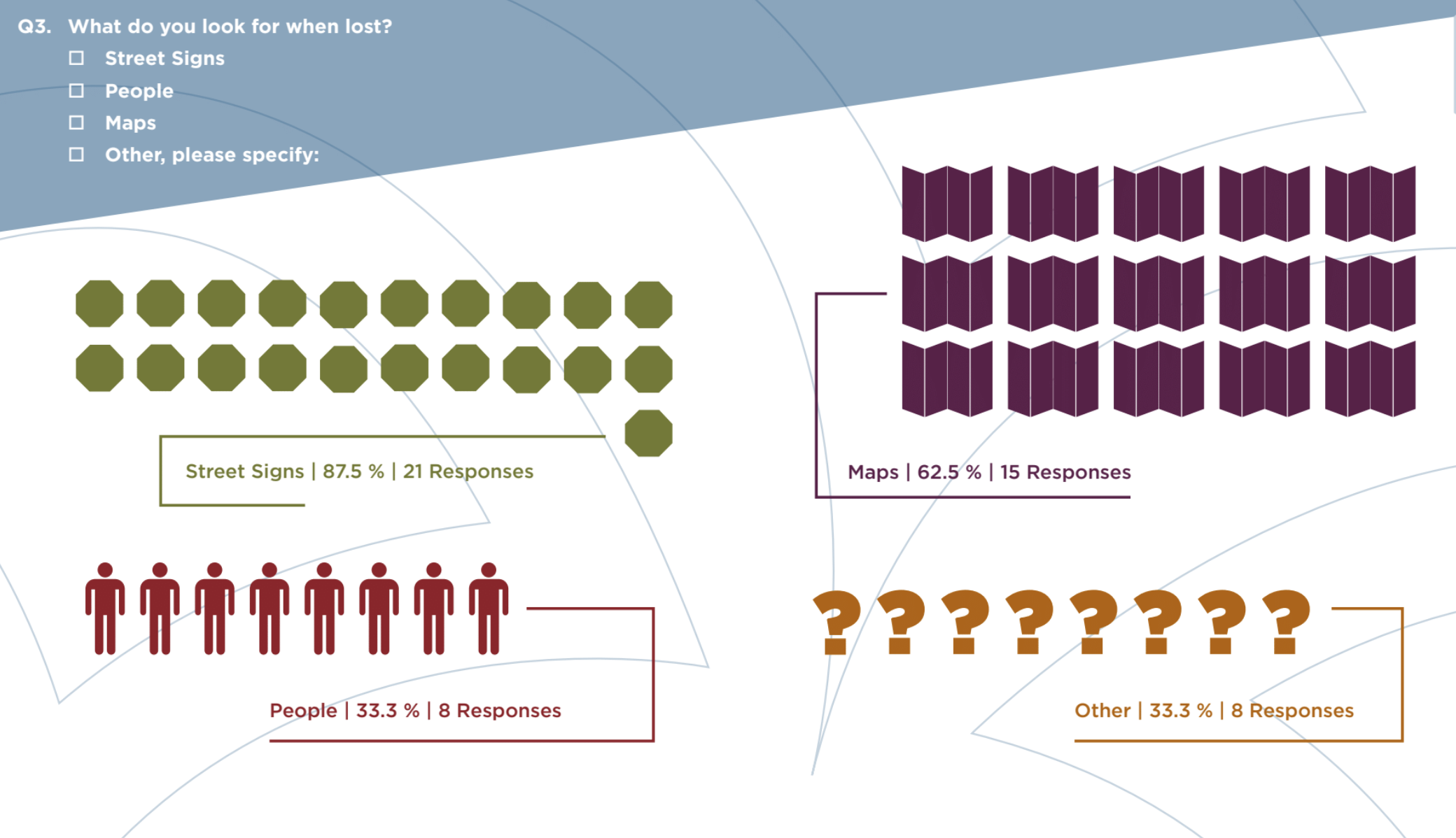
After gathering the components of my studio work, I began showing my designs to various people, both residents and people from outside the city. I also put together a survey to get feedback about my work. I asked if people were from Boston. I also wanted an idea of what people look for when they get lost in the city. Do they look for maps? People? Signs? Or maybe for something else entirely?
With my target audience for my studio work being both residents of Boston and tourists visiting the city, I drafted a survey aimed at both.I was curious to learn what either group would do when lost in a city and what people look for when they are lost.
Detail from survey responses